

A Shared Global Archaeological Fingerprint
Some Background Context
I would like to share with you some unique and ground-breaking archeological discoveries underpinning my newly published book, Discovering Ritual Meditation: Transcendental Healing and Self-Realization. This thoroughly referenced (not duplicated herein) and graphically rich book presents data-driven research from four different Sun god religion’s and their most important archaeological sites. These religions left us important information regarding their sacred ritual processes in symbolic form—arguably humankind’s best-kept and most profound secret. These ritual processes embodied the Sun god religions of ancient Egypt, pre-Colombia Meso and South America, and Southern India, three of which were made extinct via religious assimilation.
An exciting two-minute video book trailer gives you a rapid overview for a broader context, and a free KMZ file containing 450 pyramid and temple sites brings this story to life in Google Earth. Instructions for its use are included in the download.
Introduction
Four hundred and fifty (450) sacred sites and the deity art and icons from four different Sun god religions were researched using a common framework. This framework identified symbolic information embedded in temple alignments, art, icons, and other information pertaining to altered states of consciousness (ASC). These archaeological sites were once the epicenters of their religions. As such, priesthoods once resided at each, holding domain and leaving a collective fingerprint—ensured by their teaching and time-keeping needs—of their symbolically veiled ritual processes.
Site specifications captured within the research framework include:
1) Sacred space included a site’s geographical location, i.e., proximity to a lightning center, fault line, and/or volcano; its alignments relative to the overhead, moving day-night boundary (solar terminator) and the Earth’s magnetic axis (geomancy); and the place where ritual took place in some form of sensory isolation, i.e., temple sanctum, pyramid chamber, or cave/underground tunnel.
2) Sacred time included pyramid and temple alignments both locally, i.e., the equinox sunrises/sets, winter solstice sunrise (WSSR), and summer solstice sunset (SSSS), and regionally, relative to the overhead solar terminator (on the WSSR/SSSS; seen by satellite); temple-pyramid superstructure features, i.e,. 47-degree angles as solstice symbols seen with some pyramid outlines, Hindu temple gates and spires; and in their deity art and icons as sacred time symbols, i.e., V47 solstice, equinox serpents.
3) Sacred ritual involved activities undertaken to catalyze the switch in their state of consciousness, i.e., the consumption of entheogens (hallucinogens or neurochemicals from nature detailed in symbolic form in temple art as hallucinogenic flowers, fruit, and fauna), and meditation, drumming, and/or pipe music.
Sacred ritual at its essence involved sacredly timed meditation conducted in sensory isolation (silence or acoustic resonances) under the influence of hallucinogens, while potentially aligning the meditator’s body to the Earth’s magnetic fields (equinoxes, geomagnetic activity). Sacred time for the Sun god religions implied the winter solstice sunrise, summer solstice sunset, and equinox sunrises or sunsets (dependent on the phase of the moon, i.e., new or full moon).
Sacred time coincided(s) with peaks in the Earth’s electromagnetic and magnetic fields. This offered four times a year when alpha brainwaves could be maximally enhanced via entrainment processes. Alpha brainwaves are the most important brainwave signature of people in deep meditative and transcendental states of consciousness. This is where the fanciful transcendental phenomena arise, and deities, spirits, epic journeys, unity states of consciousness, god union, spiritual death/ rebirth/ resurrection (healing), and other transcendental phenomena all play out.
The research framework filtered important information from the priesthood archaeological domains, identifying two separate and related archaeological fingerprints: site alignments recorded sacred time, and their sacred ritual processes were embedded in temple art and icons in symbolic form, which included sacred time symbols. You can read more about the second fingerprint and the science and esoteric subjects involved in humans attaining and experiencing altered states of consciousness in Discovering Ritual Meditation.
A Priesthood’s Need to Accurately Tell Time Left Its Mark
Our ancient ancestors observed the sun, moon, and stars—rising, moving across the heavens, then setting—every day. They understood how the movements changed over time. They built structures on the ground—stone circles/megaliths, pyramids, and temples—to help them keep track of these movements and to accurately tell time. This was important for society’s continued prosperity and to ensure their most important religious ritual-festival dates were secured.
Ancient calendar timekeeping is best comprehended by visualizing the Earth’s daily rotation on its axis and its annual orbiting of the sun (space perspective), with the Sun’s movement along the sunrise (east) and sunset (west) horizon between the solstice extremes (ground perspective). Most (80%) site alignments delineate one or more equinox sunrise/sets, winter solstice sunrise and its corresponding summer solstice sunset. The Earth’s north-south (NS) axis is tilted 23.4 degrees from the solar system’s celestial pole, pointing toward Polaris in the northern night sky over the course of a day and year. The Earth’s North Pole, therefore, faces the Sun to its greatest degree (+23.40) from vertical on the summer solstice on the 21st of June and points farthest away from the Sun (?23.40) at the winter solstice on the 21st of December (vice versa Southern Pole). The equinoxes are midway between these solstice extremes on the spring (21st March) and autumn (21st September) equinoxes. This creates a 47-degree angular difference, which I believe was the ubiquitous solstice symbol found in art, icons, and architectural superstructures of the ancient Sun god the world over.
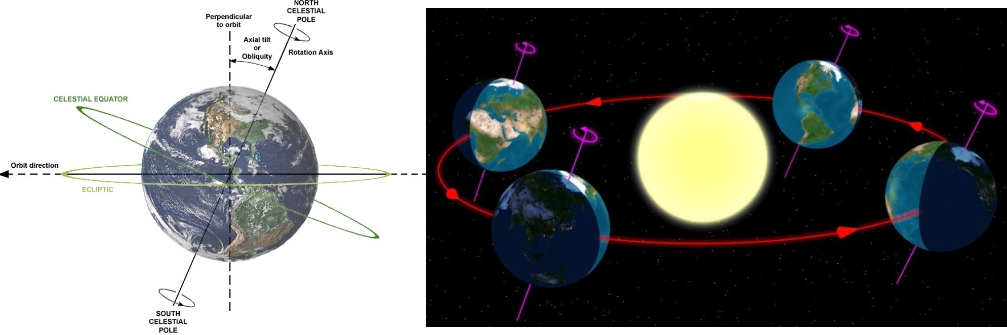
Figure 1 (A) Earth’s North Pole is tilted 23.4 degrees from the solar system’s own North Pole and rotates counterclockwise about its north-south rotational axis every 24 hours [1]. (B) The Earth orbits the Sun every 365.25 days, pointing its north-south rotational axis at the Pole Star close to the north celestial pole all day and year [2].
The Sun rises on the eastern horizon and sets on the western horizon. On the winter solstice, the sun rises and sets at its most southern extremity, and at the summer solstice at its most northern extremity. Midway between the solstices, or 91 days after a solstice, the Sun rises and sets on the spring and autumn equinoxes. On the equator, these angular differences from solstice extremes represents 47 degrees. This angle increases the farther north or south from the equator one goes.
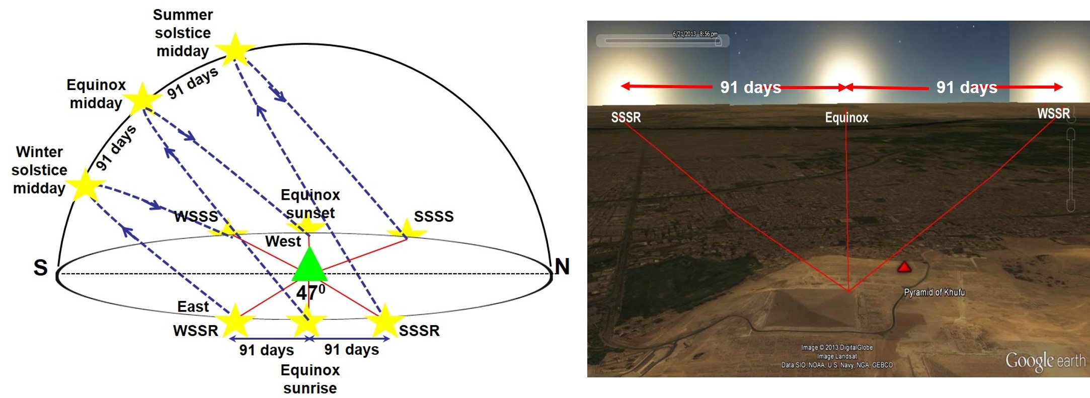
Figure 2: (A) The Sun rises in the east and follows an arc across the southern sky, reaching its daily zenith at midday before descending toward sunset on the western horizon. On the winter solstice sunrise (WSSR), the Sun rises at its most southerly point and at its most northerly point on the summer solstice sunrise (SSSR) [3]. (B) Giza’s Khufu and easterly-facing Queens’s pyramids can be used to follow the Sun’s 182-day progression from one solstice extreme to the other, with the equinox midway between. Visual sighting of the solstice enabled accurate calibrations of time, which reflected the fact that there were 365 (not 364) days per year, leap years, and precession of the equinoxes, which undermined long-term, accurate timekeeping [4].
Alignments Provided a Duality of Purpose
Organizing time and creating order from the chaos of the ancient world was critically important for ancient societies. These societies built pyramids and temples to aid accurate timekeeping. This was crucial to their prosperity and was a key pursuit of priesthoods for millennia. The commonly held view is that pyramid-temple alignments were related to timekeeping that informed the agricultural calendar. I believe this must expand to embrace the need to secure sacred time. After all, these were important places of religion first and foremost, which shared the solstices and equinoxes as their most important ritual-festival dates dedicated to their Sun gods. Accurate timekeeping was essential to propagating empire-wide religions that placed the conduct of sacredly timed rituals by their leaders-priesthoods at societies’ epicenters.
The Solar Terminator or Day-Night Boundary
Why is the solar terminator (day-night boundary viewed from space) important to this story? Firstly, it delineates a regional pyramid-temple clustering alignment principle. Secondly, it’s twice daily overhead passing generates some very interesting electromagnetic physics of relevance to human brainwave entrainment. The passing overhead solar terminator, observed on the Earth’s surface as dawn (peri-sunrise) and dusk (peri-sunset), was associated with important Sun gods and/or their progeny tasked with protecting the solar horizons, i.e., Horus, Hathor, and Aker (Egypt); Surya and Ashvin Twins (India).
The solar terminator moves across the Earth’s surface in a clockwise direction, as the Earth rotates counterclockwise, at speeds of 1,600 km/h at the equator. As this day-night boundary moves overhead, it is associated with ionization (sunrise) and deionization (sunset) processes in the upper atmosphere, which generate electromagnetic (EM) signals. These EM signals peak around the winter solstice sunrise and summer solstice sunset—which coincided with the timing of sacred rituals with transcendental intent. Viewed from space, the solar terminator changes its NS alignment over the course of a year from its extremes of +/– 23.40, as depicted below.
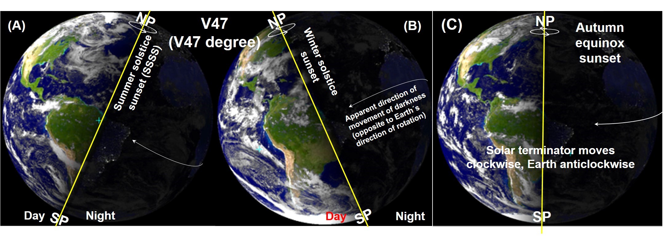
Figure 3: (A & B) The solar terminator lines (day-night boundary) observed from space move clockwise across the Earth’s surface, creating a 47-degree angle between the solstice extremes. This depicts the ubiquitous V47 solstice symbol identified in pyramid and temple architecture and deity art and icons. (C) The vertical solar terminator lines match the Earth’s lines of longitude on the equinoxes [5].
What Information Can Be Extracted from Site Alignments?
Regionally, one can observe a clustering pattern of sacred site real estate. When you see this in Figure 4 below, you will be left with many questions, not least—Was there a human colocation settlement logic across kingdoms and empires? After all, these religions were also housed in cyclically- and intermittently-enriched electromagnetic (lightning centers, active fault lines, and volcanoes) and geomagnetic fields (active fault lines and volcanoes). That implies either pure chance, at least four times, or that religion was an epicentral driving force for human settlement and colocation. More locally, pyramids and temples were aligned to the solstices (30%) and/or equinoxes (50%), which permitted accurate timekeeping and the identification of sacred time.
Regional Alignments Indicate a Colocation Settlement Logic
Something quite unexpected emerged from this project once timekeeping archaeoastronomy and solar-terrestrial processes had been understood. A clustering pattern was identified, wherein 60–95% of a region’s religious real estate is bound by a 2–7 minute wide time bandwidth associated with the solar terminator’s overhead passage on the winter solstice sunrise and summer solstice sunset, over 650–1,000km distances (see Figure 4). This means that twice a year most of a religion’s collective sacred site real estate simultaneously experienced the same enhanced extremely low frequency (ELF) electromagnetic (EM) fields (Schumann resonances) overhead. Interestingly, this also coincided with the timings of their most important ritual-festival dates dedicated to their Sun gods.
How or why did this happen? I’d love to hear your views on this.
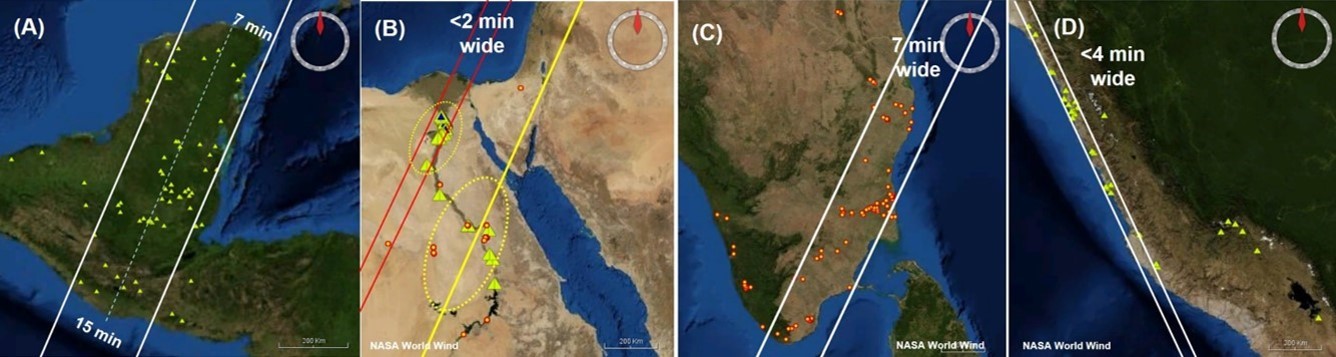
Figure 4: Sun god religions’ sacred site real estate is clustered into regional alignments delineated by the winter solstice sunrise and summer solstice sunset solar terminators. (A) Ancient Maya located 60%–85% within a 7–15 minute wide solar terminator bandwidth 900km long. (B) Ninety-five percent of Old Kingdom pyramids lie within a <2 minute wide terminator between Cairo to Faiyum (80km). (C) Seventy-four percent of Divya Desam temples lie within 7-minute wide solar terminator 650 kilometers long; three-quarters of these also delineated a V47-degree solstice, symbolizing pyramid gate superstructure and temple spire. (D) Ninety-seven percent of major pre-Inca/Inca sites along the Peruvian coast lie underneath a 4-minute WSSR and SSSS solar terminator over 1,000km distances [6].
Additionally, all four religions were located in (pre-Colombia Meso/South America, South India), or proximate to and on the same longitude (Egypt), as the global lightning centers. The lightning centers electrically discharge the inner magnetosphere, which accumulates solar plasma charge via magnetic field reconnections with the interplanetary magnetic field and ionization processes in the upper ionosphere. Lightning generates Schumann resonances, which represent a band of extremely low frequency (ELF) electromagnetic (EM) spectral peaks related to the Earth’s overhead cavity dimensions—that is EM waves up to 85km in amplitude and the Earth’s circumference in wavelength, and harmonics thereof. Schumann resonance spectral peaks also correspond to the different brainwave frequency bands—alpha, beta, delta, and gamma. Science shows how Schumann resonances can entrain (enhance) specific brainwave frequency bands and alpha brainwaves appear most susceptible to external enhancements (amplitudes; power). All this article’s science is well referenced in my book. You can view hyperlinks to all references cited on my website.

Figure 5: (A) Lightning activity, concentrated into three main mid-latitude regions, is responsible for generating ELF/VLF EM fields as lightning’s byproduct. This world map shows the frequency of lightning strikes (flashes per km² per year) from 1995–2003 (red-yellow highest flash rates) [7]. (B) Intermittently active fault lines and volcanoes, typical of the Guatemalan Highlands with its 37 volcanic peaks, generate enhanced electromagnetic and magnetic wave fields, and were important locations of Mesoamerican Sun god religions (Olmec, Maya) [8].
Pre-Colombian Meso/South American sites also reside within intermittently active fault lines and volcanic zones. Earthquakes (EQ) and active volcanoes are important local generators of intermittently enhanced ELF electromagnetic waves and magnetic fields. Mounting data highlights that EQ epicenters emit ultra/extremely low frequency EM fields in the weeks preceding an earthquake and/or volcanic eruption due to physical processes within the Earth’s crust. Enhanced ELF fields are detectable weeks before and leading up to big earthquakes, i.e., > Richter scale 6.0 within a 70–80 kilometer radius of the EQ epicenter. That’s why places like Santiago de Atitlan (Guatemala) were once important places of Mayan shaman activity with its frequent cyclical lightning, intermittent earthquakes, and volcanic activity, as well as the twice yearly solstices and equinoxes.
Solar Terminator Discussion
These solar terminator alignments represent a serious amount of sacred site real estate, falling within range of a common theme. Yes, these patterns could have occurred as a result of pure chance (more than four times) or as a function of geographical restrictions, such as the Andes Mountains, the shape of a region’s landmass, and its proximity to rivers and natural protections. However, when you view this alignment theme from different altitudes (regional and local), combined with sacred time symbols embedded in each religion’s temple art and icons (V47-degree solstice, equinox serpents; see Chapter 5 of Discovering Ritual Meditation), and combined with the fact that all these religions honored and worshipped their most important Sun gods at these sacred times (equinoxes, solstices), a composite and consistent picture emerges. This fingerprint begs for an explanation beyond mere coincidence, especially when these regionally clustered sites simultaneously experienced the same enhanced electromagnetic fields—at the winter solstice sunrise and summer solstice sunset solstice as the solar terminators passed overhead, which coincided with sacred ritual timings.
The causation and implications of these enhanced Schumann resonances and magnetic fields are reviewed more fully in Chapters 6–9 of Discovering Ritual Meditation. Suffice to say, the science highlights benefits in modulating important parts of the human brain associated with deep meditative and transcendental states of consciousness, which ties in with sacred ritual’s outcome. This offered(s) the potential to switch one’s state of consciousness from being awake to a transcendental state. This capability is biologically enabled in humans, as part of the four states of consciousness humans are genetically gifted—awake, asleep, dreaming, and ASC.
Marking Solstices and Equinoxes
Marking the solstices and equinoxes typically utilized a building’s main foundational/structural lines placed between the observer and the eastern (sunrise) or western (sunset) horizon. The key starting point was observation and marking the sunrise/set at a solstice extreme or equinox. A variety of techniques were used—sighting solstice sunrises/sets and midday solar zeniths (south), counting days from solstice extremes (91 days to the equinoxes), and use of a gnomon (sundial). A close relationship must have existed between priesthood timekeepers and temple architects both to enshrine these alignment principles and for this know-how to be state- or empire-wide. This knowledge effectively formed the basis of the solar and/or solar-lunar calendars.
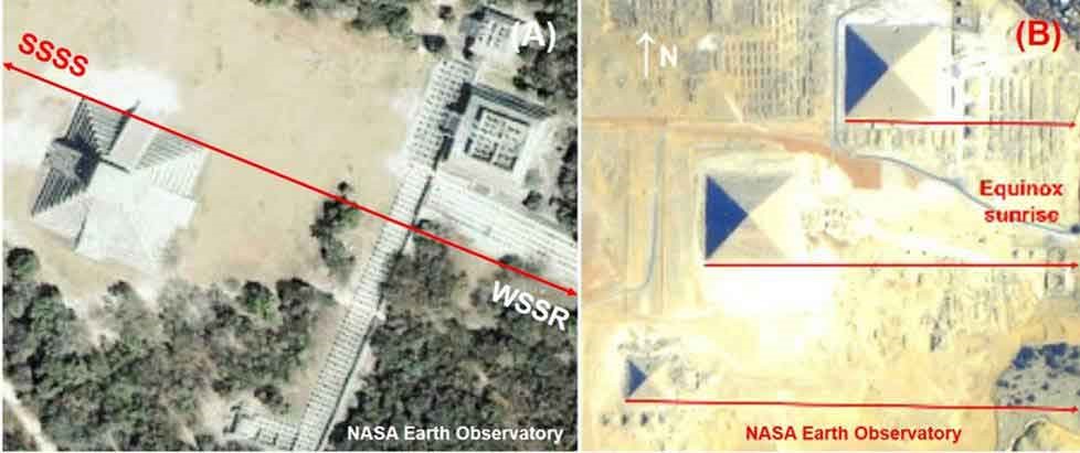
Figure 6: Equinox and solstice alignments common to Sun god sacred sites. (A) The pyramid of Kukulkan and its proximate structures at Chichen Itza (Mexico) align with the WSSR and SSSS. (B) The main pyramids at Giza (Cairo, Egypt) align with the equinox sunrises and sunsets while also providing solstice alignments via its eastern-situated Queens pyramids (see Figure 2B) [9].
Local Pyramid and Temple Alignments
Of the 450 pyramids and temples reviewed for this project, 86 were pre-Colombia Mesoamerican pyramids; 40 were Inca/pre-Inca pyramids, temples, and huacas; 103 were Egyptian pyramids; 114 were Egyptian temples; and 106 were Divya Desam temples dedicated to Lord Vishnu, located in Southern India. These locations include their most important sacred sites. At the macro-level, approximately half were equinox-aligned and a third solstice-aligned. You can view this for yourself using the Google Earth KMZ file download, as well as viewing a select number of solar calendar structures and the simulated sunrises/sets they depict (Giza, Tiwanaku, and Chankillo).
View Famous Places Demonstrating This Alignment Fingerprint
1) Mesoamerica: Cholula, Teotihuacan, Monte Alban, Tikal, Calakmul, Yaxha, Chichen Itza, Uxmal, Palenque, Yaxha, Aguateca, and Tak Alik Abaj.
2) Ancient Egypt’s pyramids: Giza (Pyramids of Khafre, Khufu, and Menkaura), Red Pyramid, Bent Pyramid, Step Pyramid of Djoser, Pyramid of Niuserre Ini, Neferirkare, Sahure, Meidum, White Pyramid, Black Pyramid, Pyramids of Amenemhat III, and Senusret I, II, and III.
3) Ancient Egypt’s Sun god temples of: Amun, Maat, and Khonsu (Karnak Temple Complex), Hatshepsut’s, Tuthmosis III’s and Mentuhotep II, Amenhotep III, Nyuserre-Ini, Ahmose, Satet, Hathor, and Isis (Dendera complex), Rameses II (Abu simbel), and Aten.
4) Pre-Inca Kingdoms and the Inca Empire in South America: Caral, Chavin de Huantar, Cahuachi (Nazca), Pachacamac, Huacas del Sol and la Luna, Las Haldas, Napena, Chan, Tucume, Tiwanaku, Sacsayhuamán, Machu Picchu, and Ollantaytambo.
5) India’s Divya Desam temples: 106 of the 108 temples.
Each religion biased a particular alignment principle and/or architectural feature to delineate or specify sacred time. Cardinal alignments, greeting the equinox sunrises/sets, dominated ancient Egypt’s Old and Middle Kingdom pyramids (90%) and Hindu’s Divya Desam temples (90%), as well as other Hindu temples.
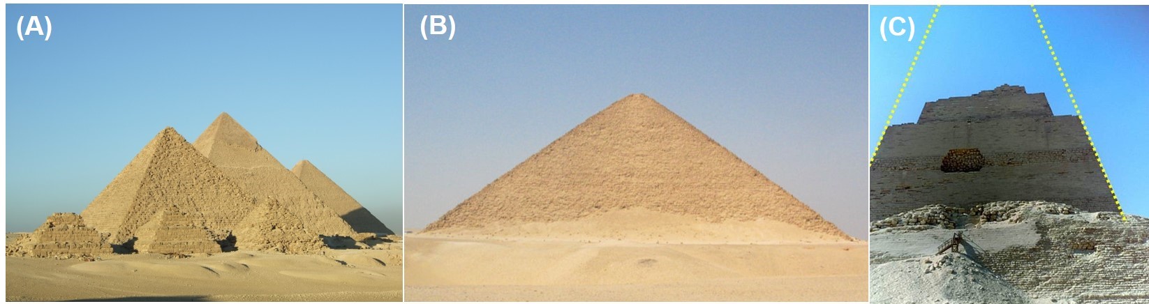
Figure 7: Three of Egypt’s oldest, largest, and best preserved pyramids. (A) Pyramids at Giza, Menkaure (foreground), Khafre* (midground), Khufu* (background right) [10]. (B) The Red Pyramid* located southwest of Giza on the Dahshur necropolis [11]. (C) The cardinally aligned Pyramid of Meidum has an inner-pyramid structure depicting a V47-degree angle, reminding us of the designer’s awareness of solstices and equinoxes, and its sacred time symbolism [12].
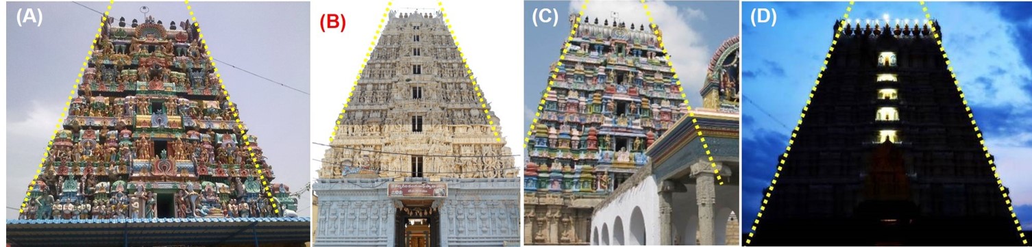
Figure 8: Dravidian-style temple gopurams (gateways) associated with Southern India Divya Desam temples (and Paadal Petra Sthalam temples) highlight a common V47-degree architectural superstructure (V47 solstice symbol), exemplified by: (A) Parimala Ranganathar Temple, (B) Sri Ranganathaswamy Temple, (C) Brahma Temple, and (D) Varadharaja Perumal Temple [13].
Three-quarters of the ancient Divya Desams temples dedicated to Lord Vishnu also used a 47-degree V-shape temple spire, and/or a flat-topped, highly ornate pyramid gate structure (gopurams) on at least one of the temple’s main gates. This V47 structural outline is the same angle used in the pyramid(s) at Meroe (Sudan) and Meidum (Egypt). This ubiquitous V47-degree angle represents the solstice symbol.
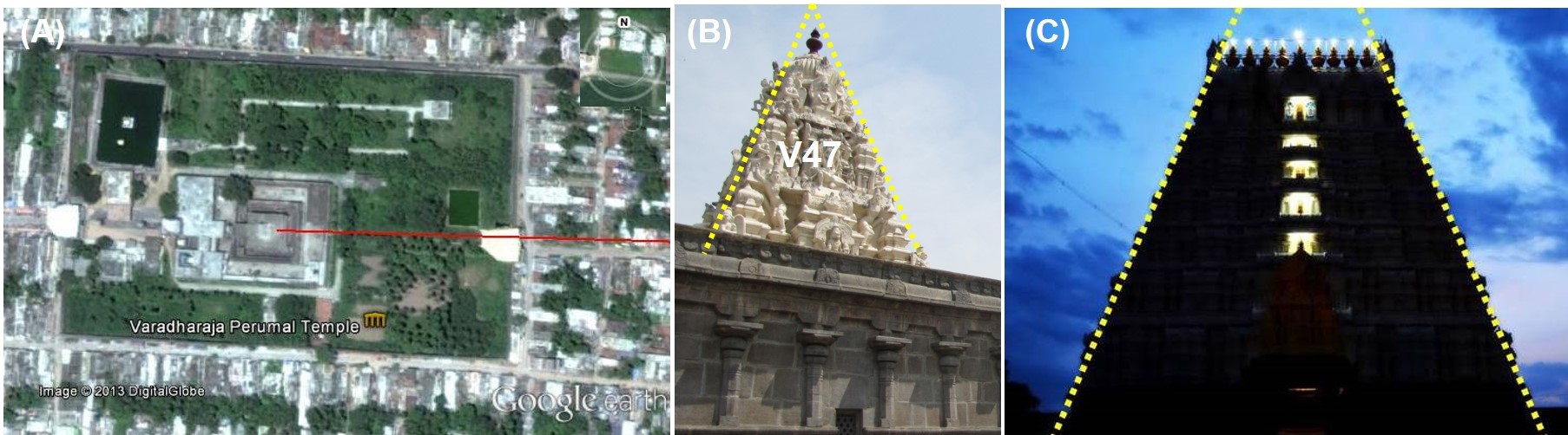
Figure 9: Varadharaja Perumal Temple, a famous Hindu temple dedicated to Lord Vishnu located in the holy city of Kanchipuram (India), exemplifies Hindu’s Divya Desam temples. (A) The Varadharaja Perumal Temple outline seen using Google Earth. In common with 90 percent of Divya Desams, it is cardinally aligned to greet the equinox sunrise/set. (B) Divya Desam Temples typically feature a V47-degree spire. (C) Three-quarters of Divya Desam temple gateways embed the V47-degree solstice angle in at least one of their superstructures [14].
Whereas urban and/or site alignments demarcating the winter solstice sunrise and its corresponding summer solstice sunset dominated the pre-Colombian Mesoamerican (70%), pre-Inca (Inca South American pyramids, temples, and huacas (88%)), and Egyptian temple (30%; Luxor; New Kingdom, especially 18th Dynasty) landscapes.
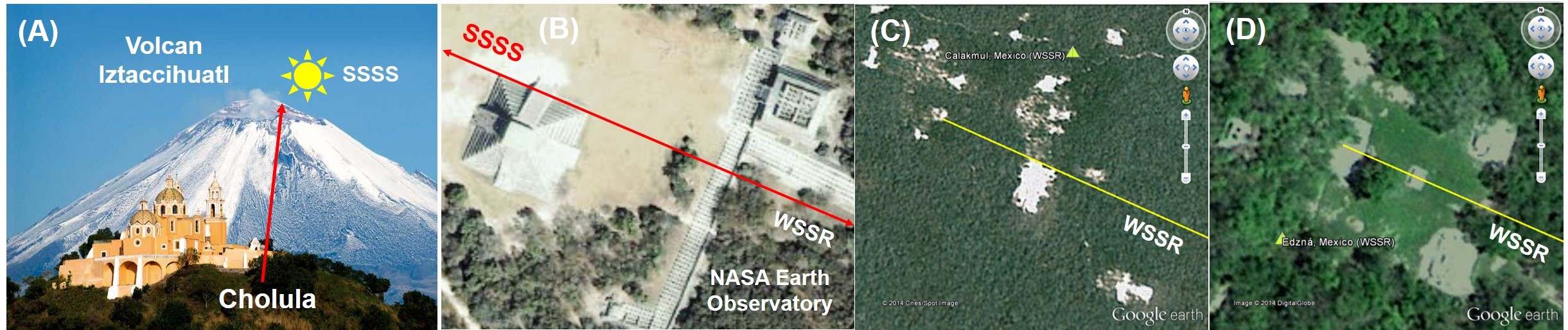
Figure 10: Mesoamerica biased the winter solstice sunrise. (A) The Great Pyramid of Cholula (Mexico), one of the largest pyramids by volume, is aligned with the WSSR/SSSS, with the sun setting behind Volcan Iztaccihuatl on the SSSS [15]. (B) The Temple of Kukulkan at Chichen Itza (Mexico) faces the WSSR and SSSS [16]. (C) The Calakmul (Mexico) site plan faces the WSSR/SSSS [17]. (D) Parts of the Edzná (Mexico) site face the WSSR. This site was occupied for over nearly 2,000 years (400 BCE–1500 CE) [18].
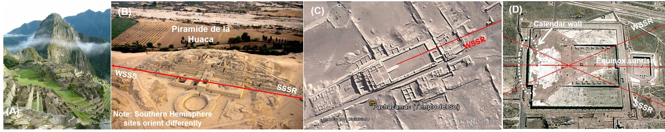
Figure 11: Pre-Inca/Inca South America sacred sites aligned with the WSSR/SSS except where the Andes Mountains precluded its true horizon observation. (A) Machu Piccu faces the WSSR, with the sun rising between a mountain ridge cleft, making the solstice determination easy and accurate—weather permitting [19]. (B) Caral (2,600 BCE), one of the oldest South American pyramid sites, is aligned with the SSSR and WSSS. Piramide de la Huaca nicely highlights its axial alignment to this alignment [20]. (C) Pachacamac’s Templo del Sol faces the WSSR and SSSS [21]. (D) Tiwanaku’s Kalasasaya platform offers the ability to delineate all solstice and equinox sunrises and sunsets from a single observation point. This platform also contains the Gateway of the Sun, Bennet’s Monolith (eastern gate), and a Calendar wall (west) [22].
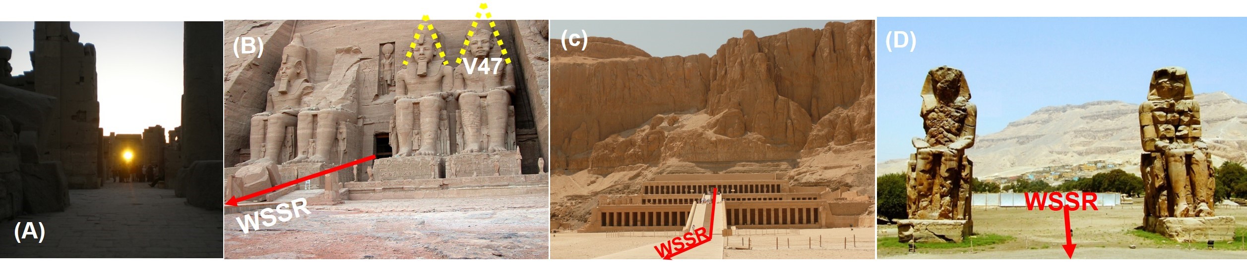
Figure 12: Egypt’s Sun god temples biased the WSSR/SSSS alignment. (A) Karnak’s Temple of Amun permits the sighting of the WSSR through an aperture in the eastern temple structure from along its WSSR aligned axis [23]. (B) The Great Temple of Rameses II’s (Abu Simbel) location (solar zenith on the summer solstice is directly overhead), WSSR alignment, and pharaoh statues are heavily laden with sacred time symbols [24]. (C) The Temple of Queen Hatshepsut sits at the foot of the cliff face at Deir el Bahari on the west bank of the Nile with its central axis facing the WSSR [25]. (D) The Temple of Amenhotep III’s central axis and Colossi of Memnon face the WSSR [26].
Mesoamerican Site Alignments with Volcanoes
Pursuing the settlement logic still further, I’d like to draw your attention to some other less dominant geographic location attributes. These locations are also underpinned by an intermittent enhancement of environmental electromagnetic and geomagnetic fields. One-fifth of Mesoamerican sites reviewed used horizon volcanoes to assist pyramid, temple, or site alignments. This indicates site planners considered these features important in site selection, in addition to natural protections and proximity to rivers. Solstice volcano alignments also play an important role in the large Moai stone statues on Easter Island and Borobudur, the ancient Buddhist stupa in Java. Was this alignment principle of ritual benefit or simply an additional marker? Once again, I’d love to hear your views on this.

Figure 13: Mesoamerican sites, particularly around (A) Mexico City and (B) the Guatemala Highlands, frequently used a volcano on the horizon to align the site with one of the solstice sunrises or sunsets. This means the sun rose or set behind the volcano’s crater on the winter solstice sunrise (WSSR), summer solstice sunset (SSSS), winter solstice sunset (WSSS), and summer solstice sunrise (SSSR) [27].
Conclusions
The Sun god religions of ancient Egypt, Meso and South America, and India built pyramids and temples specifically aligned with the solstices and equinoxes, which coincided with sacred time. Moreover, at the regional level, the majority of a religion’s sacred site real estate was clustered into 2–7 minute wide time bandwidths delineated by the passing overhead solar terminator on the WSSR/SSSS and over distances of 650–1,000km. In addition, these religions were also housed in, or proximate to and on the same longitude as, the global lightning centers. Two of these religions were also housed over intermittently active fault lines and/or near intermittently active volcanoes.
The commonality underpinning this colocation is the simultaneous experience of cyclical and intermittently enhanced ELF electromagnetic/ geomagnetic fields, both known to entrain enhanced alpha brainwave amplitudes over the frontal brain. The significance of this relates to enhancement (via brainwave entrainment) of alpha brainwave generating processes, which are housed in the frontal brain (prefrontal cortex and angulate cingulate cortex). These frontal brain processes govern our executive control functions and emotional regulation processes, which are considered gateway processes involved in humans’ attaining of deep meditative and transcendental states of consciousness. I, therefore, conclude that the Sun god religions’ ritual needs were a key driving force behind human colocation settlement, which facilitated state- or empire-wide religions. This raises many questions, not least the possibility of humans being biologically enabled to experience non-local communication in transcendental states of consciousness by simultaneously accessing these states of consciousness.
Bibliography & Attributions
[1] Earths 3 rotations: original work by Dennis Nilsson / Wikimedia Commons / CC-BY-3.0.
[2] Earth’s Pole Star pointing: original image by Tau?olunga / Wikimedia Commons / Public Domain-CC0 1.0 Universal. http://en.wikipedia.org/wiki/File:North_season.jpg
[3] Carlton Brown / Public Domain
[4] Image provided by Google Earth and partners; Image DigitalGlobe 2013, Image Landsat, data SIO NOAA US Navy NGA GEBCO. All rights reserved.
[5] Composite image created by Carlton Brown / Public Domain. Composed of (A & B) Cropped images repositioned to accentuate V47 solstice angle, with additional annotation overlays. Original images by Tom Ruen (Full Sky Observatory) / Wikimedia Commons (Public Domain), http://en.wikipedia.org/wiki/File:Seasonearth.png.
[6] Composite image created by Carlton Brown / Public Domain. of the Sun god religions 3D positioning relative to the solstice solar terminators comprising modified original works (cropping, annotations, additions; by the author); (A-D) original works by NASA World Wind / Public Domain.
[7] Global lightning centers: Citynoise at en.wikipedia / Wikimedia Commons / CC BY-SA 3.0. http://en.wikipedia.org/wiki/File:Global_lightning_strikes.png.
[8] Nmarritz / Wikimedia Commons / CC BY-SA 2.0.
[9] Composite image created by Carlton Brown of Mesoamerican site alignments comprising modified original works (annotations, cropping); (A) Chichen Itza: a modified image created by Carlton Brown / Public Domain. original work by NASA Earth Observatory / Public Domain. http://eoimages.gsfc.nasa.gov/images/imagerecords/5000/5349/chichenitza_iko_2001064_lrg.jpg. (B) Giza: a modified image created by Carlton Brown / Public Domain. original work by NASA Earth Observatory / Public Domain. http://earthobservatory.nasa.gov/IOTD/view.php?id=79253.
[10] Carlton Brown / Public Domain
[11] Chipdawes / Wikimedia Commons / public domain. http://en.wikipedia.org/wiki/File:RedPyramid.JPG
[12] Original work by Roland Unger / Wikimedia Commons / CC-BY-SA-3.0-2.5-2.0-1.0. Modified image (V47 solstice angle depiction) created by Carlton Brown / Public domain citing original work.
[13] Original works by: (A) Krishna Kumar Subramanian / Wikimedia Commons / CC0 1.0. http://commons.wikimedia.org/wiki/File%3AParimala_Ranganathar_Temple.jpg. (B) YVSREDDY / Wikimedia Commons / CC-BY-SA-3.0. http://commons.wikimedia.org/wiki/File%3ASri_Ranganathaswamy_Temple%2C_Galigopuram%2C_Nellore_YS.JPG. (C) Coolsangamithiran / Wikimedia Commons / CC-BY-SA-3.0. http://commons.wikimedia.org/wiki/File%3ABrahma_temple.jpg. (D) Rathishkrishnan / Wikimedia Commons / CC-BY-SA-3.0. http://commons.wikimedia.org/wiki/File:Varadharaja_Perumal_Temple_Gopuram_View_At_Night.jpg. Modified images (A-D; V47 degree solstice symbol) created by Carlton Brown / Wikimedia / CC0 1.0, CC-BY-SA-3.0 or Public Domain.
[14] Original works by: (A) Google Earth & Partners / see their policy. (B) Muthukumaran pk / CC-BY-SA-3.0 / Wikimedia Commons. http://commons.wikimedia.org/wiki/File%3AVaradarajaperumal_temple%2C_Thirubuvanai%2C_Puducherry%2C_India_(7).JPG. (C) Rathishkrishnan / Wikimedia Commons / CC-BY-SA-3.0. http://commons.wikimedia.org/wiki/File:Varadharaja_Perumal_Temple_Gopuram_View_At_Night.jpg. Modified images (annotations, cropping; by the author) created by Carlton Brown / Public Domain or Wikimedia / CC-BY-SA-3.0.
[15] Original work by Jflamenco / Wikimedia Commons / CC BY-SA 3.0. http://commons.wikimedia.org/wiki/File:Cholula-puebla1.jpg. Modified image created by Carlton Brown of Great Pyramid of Cholula & Volcan Iztaccihuatl (Mexico) (annotations, cropping; by the author); (A) a modified image created by Carlton Brown / Wikimedia / CC-BY-SA-3.0.
[16] NASA Earth Observatory / Public Domain
[17] Google Earth & Partners / See Google Earth use policy.
[18] Google Earth & Partners / See Google Earth use policy.
[19] Allard Schmidt / Wikimedia Commons / CC-BY-SA-3.0
[20] Original work by Villa de omas / Wikimedia Commons / CC BY-SA 3.0. http://commons.wikimedia.org/wiki/File:Pir%C3%A1mides_de_Caral_(III_milenio_a._C.),_sede_de_la_primera_civilizaci%C3%B3n_del_continente_americano..jpg. Modified image created by Carlton Brown / Wikimedia / CC-BY-SA-3.0 (annotations, cropping).
[21] Google Earth & Partners / See Google Earth use policy.
[22] Google Earth & Partners / See Google Earth use policy.
[23] Furlong, D – Egyptian Temple Orientation – http://www.kch42.dial.pipex.com/egyptarticle_temple_orient1.html
[24] Original work by Dennis Jarvis / Wikimedia Commons / CC BY-SA 2.0. http://commons.wikimedia.org/wiki/File:Flickr_-_archer10_(Dennis)_-_Egypt-10C-063.jpg. Modified image created by Carlton Brown / Wikimedia / CC BY-SA 2.0 (annotations, cropping; by the author).
[25] Aligatorek / Wikimedia Commons / CC-BY-SA-3.0. http://commons.wikimedia.org/wiki/File:Alig_Deir_el_Bahari_314.jpg.
[26] Original works by Roweromaniak / Wikimedia Commons / CC-BY-SA-2.5-poland. http://commons.wikimedia.org/wiki/File:Teby_Kolosy_Memnona_C18-24.jpg Modified image (cropped, annotated) created by Carlton Brown / Wikimedia Commons / CC-BY-SA-2.5-poland.
[27] Original works by: (A) Satellite imagery by NASA World Wind / Public Domain, and other smaller volcano images include; original works by Eneas De Troya / Wikimedia / CC BY 2.0. http://commons.wikimedia.org/wiki/File:Pico_de_Orizaba_desde_Xalapa.jpg, Jose Alonso / Wikimedia / CC BY 3.0. http://commons.wikimedia.org/wiki/File:Malinche.jpg, AlejandroLinaresGarcia / Wikimedia Commons / CC-BY-SA-3.0-2.5-2.0-1.0. (B) NASA World Wind / Public Domain, and other smaller volcano images include; original works by; Norm Banks / Wikimedia Commons / Pubic Domain. http://commons.wikimedia.org/wiki/File:Volcan_Tajumulco_1987.jpg, Stan Shebs / Wikimedia Commons / CC-BY-SA-3.0. http://commons.wikimedia.org/wiki/File:Guatemala_Volcano_Fuego.jpg, Derick Leony / Wikimedia Commons / CC-BY-SA-2.0. http://commons.wikimedia.org/wiki/File:Volcan_de_Agua_in_Guatemala.jpghttp://commons.wikimedia.org/wiki/File:PopoAmeca.JPG, Jflamenco / Wikimedia Commons / CC BY-SA 3.0. http://commons.wikimedia.org/wiki/File:Cholula-puebla1.jpg. Composite images created by Carlton Brown of Mesoamerican volcano alignments comprising a number of modified pieces of original work (annotations, cropping, formatting; by the author);


